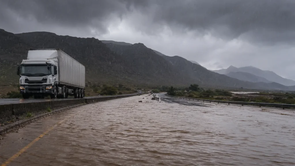
Storm flooding fleet routes across two provinces as the second major weather event in 30 days hits the same infrastructure that hasn’t finished recovering from the first. SAWS issued an Orange Level 8 warning — the highest active alert — for the Garden Route and Eastern Cape coast up to East London. Schools closed in six districts: Nelson Mandela, Sarah Baartman, and Buffalo City in the Eastern Cape plus Eden and Central Karoo in the Western Cape. The N2 freight corridor from George to East London faces flooding, bridge closures, and mudslides. Over 301mm of rain has fallen in parts of the Garden Route. Meiringspoort (N12) remains closed indefinitely from the May national disaster. Fleet operators who rerouted through the Garden Route after Meiringspoort’s closure now face those alternative routes flooding too.
This is the second report in our severe weather fleet disruption series. Our May analysis documented 61 roads closed and Meiringspoort shut. Today’s article maps the new storm flooding fleet routes face, explains why the second hit compounds the first, and provides the immediate actions fleet operators must take while the Orange Level 8 warning remains active.
What Is Happening Now: The Storm Flooding Fleet Routes Face Under Orange Level 8
Specifically, SAWS warns of “disruptive rainfall leading to flooding of roads and bridges, danger to life due to fast-moving streams and rivers, and causing major roads to be closed.” The cut-off low pressure system intensified over the southern coast on Wednesday 3 June and continues through Thursday 4 June.
The warning zones affecting storm flooding on fleet routes
Orange Level 8 (highest): Eastern Garden Route between Mossel Bay and Plettenberg Bay, plus the Eastern Cape coast from the Garden Route border to East London. This covers the N2 freight corridor. Orange Level 5: East London to Morgan Bay — mudslides, flooding, and displacement of settlements. Yellow Level 4: Eastern parts of the Western Cape excluding the south-eastern extremes. Yellow Level 2: Disruptive snow over northern Eastern Cape highlands, causing icy roads and traffic disruptions. Additionally, Level 2 severe thunderstorm warnings apply to Gauteng, Limpopo, and Mpumalanga.
Schools closed in six districts — fleet delivery schedules disrupted
Daily Maverick confirms that education authorities suspended classes across six districts for Wednesday and Thursday. The closures signal the severity of conditions on the ground. Furthermore, when schools close, staff travel patterns change, retail demand shifts, and the logistics chain that serves educational institutions pauses. Fleet operators delivering to schools, catering services, or municipal facilities in these districts should expect cancelled or rescheduled orders.
Homes and infrastructure already damaged before the storm peaks
Scrolla.Africa reports that homes and infrastructure in parts of the Eastern Cape sustained damage before the storm reached peak intensity. The Garden Route District Municipality activated its multi-agency command centre — the same centre that coordinated the May national disaster response. Consequently, emergency services that are still managing May flood repairs now face a new event with stretched resources and fatigued personnel.
The Second Hit: Why This Storm Flooding Compounds the Fleet Route Damage From May
Importantly, the May 2026 national disaster and the June cut-off low are striking the same geography within 30 days. For fleet operators, this creates compound damage that exceeds either event individually.
Meiringspoort still closed — fleet alternatives now flooding too
First, our May analysis documented that the N12 through Meiringspoort closed indefinitely after structural damage to the pass. Fleet operators travelling between the Central Karoo and the Garden Route rerouted through the Outeniqua Pass (N12/N9) or via the coast (N2). Crucially, the N2 coastal route is now under Orange Level 8 conditions. The Outeniqua Pass faces Yellow Level 4 rainfall. Fleet operators who built their post-May routing around these alternatives now face the alternatives themselves becoming impassable. The “Plan B” is flooding.
Roads repaired after May face resubmersion on fleet routes
Second, of the 61 roads closed during the May disaster, many reopened with temporary repairs — gravel fills, emergency bridging, and patched surfaces. These temporary repairs are particularly vulnerable to a second flooding event. Importantly, a road that survived May’s rainfall at 80% structural integrity may fail completely under June’s additional loading. Fleet operators should not assume that a road open yesterday remains open today. Real-time traffic information and GPS tracking provide the only reliable view of current route availability.
301mm of rain in the same catchment area as storm flooding hits fleet routes
The Watchers documented 301mm of rainfall during the May event. The Kouga Dam reached 113% capacity, triggering evacuations in the Gamtoos Valley. Dams, rivers, and catchments that absorbed May’s volume now have reduced capacity to absorb June’s rainfall. Similarly, saturated soils cannot drain additional water. The result: rivers rise faster, roads flood sooner, and bridge levels exceed safe thresholds at lower rainfall totals than May required. The same 50mm of rain in June produces worse flooding than 50mm in May because the landscape is already waterlogged.
Which Fleet Routes Face the Worst Storm Flooding Right Now
Accordingly, fleet operators need corridor-specific intelligence to make routing decisions. Here is the current assessment by route.
N2 George to East London: storm flooding on SA’s coastal fleet route
Specifically, the entire N2 stretch from George to East London falls within the Orange Level 8 zone. This is a primary freight route connecting the Western Cape to the Eastern Cape, KwaZulu-Natal, and Gauteng. Bridges across the Storms River, Bloukrans River, and Kei River face flooding risk. Fleet operators should not dispatch vehicles onto this corridor until SAWS downgrades the warning. Vehicles already on the N2 between these points should pull over safely and contact the control room. The alternative inland route via the N9 through Graaff-Reinet adds approximately 300 km but avoids the coastal flooding zone.
N12 Meiringspoort: still closed from May — no fleet route available
Meanwhile, Meiringspoort remains closed indefinitely. The June storm adds no new information — the pass was already impassable. However, fleet operators should note that the pass closure forces all Central Karoo traffic onto the N2 coastal route or the N9 inland route, both of which now face weather disruption. Effectively, there is no guaranteed open route between the Central Karoo and the Garden Route until both the storm passes and SANRAL confirms road conditions.
Garden Route local roads: fleet delivery network at risk
Furthermore, local roads in Knysna, Bitou (Plettenberg Bay), George, and the Langkloof face the most concentrated flooding risk. These roads serve the last-mile delivery network for retail, agricultural, and construction fleets. In May, secondary roads in these areas closed for days after the main event ended. Fleet operators making local deliveries in the Garden Route should suspend non-essential dispatches until conditions improve. Essential deliveries should proceed only with confirmed route availability and active GPS tracking.
Eastern Cape highlands: icy roads threaten fleet truck safety
Additionally, SAWS issued a Yellow Level 2 warning for disruptive snow over northern Eastern Cape highlands. Icy roads affect truck braking distances and stability, particularly for loaded freight vehicles on mountain passes. Fleet operators routing through the Barkly Pass, Penhoek Pass, or any highland section should verify conditions with local traffic authorities. Notably, a loaded truck on an icy mountain pass faces a fundamentally different risk profile than the same truck on a dry road — the stopping distance can triple.
Immediate Actions: What Fleet Operators Must Do While Storm Flooding Closes Routes
Clearly, the Orange Level 8 warning demands immediate operational response. Every hour of delay increases the risk of a vehicle entering a flooded zone.
Check every vehicle position on storm-affected fleet routes now
Open your tracking platform immediately. Identify every vehicle currently on the N2 between George and East London, on Garden Route local roads, or approaching the Eastern Cape coast. Contact those drivers directly. Instruct them to pull over safely if conditions deteriorate. Do not wait for the driver to call you — proactive communication saves vehicles and lives.
Do not dispatch into Orange Level 8 zones
Hold all dispatches to affected areas until SAWS downgrades the warning. A delivery delayed by 24 hours costs less than a vehicle submerged in floodwater. Flooded vehicles face engine hydrolocking, electrical system failure, cargo damage, and recovery costs that exceed R100,000 per vehicle. Brief every dispatcher: no vehicle enters a Level 8 zone without explicit fleet manager authorisation and confirmed route availability.
Reroute via inland corridors where possible
The N1 inland corridor remains the safest alternative for long-haul fleet routing. Cape Town to East London via the N1 through Beaufort West and Cradock avoids the worst coastal flooding. The distance increases significantly but the route stays clear of Orange Level 8 conditions. For shorter routes within the Garden Route, wait for conditions to improve — there are no safe alternatives when both the N2 and Meiringspoort are impassable.
Protect cold chain and time-sensitive fleet cargo
Cold chain deliveries face the highest spoilage risk during storm flooding on fleet routes. Refrigerated cargo that requires delivery within 6 to 12 hours cannot wait 24 to 72 hours for roads to reopen. Fleet operators carrying perishable goods should contact receiving clients immediately to negotiate extended delivery windows or identify alternative supply sources closer to the destination. Document every spoilage event with GPS data and dashcam footage for insurance claims.
Ensure dashcams and tracking remain active for fleet insurance evidence
If a vehicle sustains flood damage, the insurance claim depends on evidence. Dashcam footage showing the vehicle encountering sudden flooding — rather than deliberately driving through a marked flood zone — distinguishes a covered claim from a rejected one. GPS route data proving the driver followed an approved route strengthens the claim further. Accordingly, confirm that every vehicle in affected areas has active dashcam recording and cloud upload enabled before conditions worsen.
Technology That Protects Fleet Operations During Storm Flooding on Routes
Notably, the same tracking and monitoring platform that protects against hijacking serves a critical role during severe weather — with capabilities that become urgent during Orange Level 8 events.
DigitFMS integrates GPS tracking with geofencing, AI dashcams with cloud upload, route management, and real-time driver communication on a single dashboard. When conditions deteriorate, the fleet manager geofences the affected zone within minutes. Every vehicle approaching the zone receives an automated alert. Drivers already inside the zone appear on the dashboard with their exact position. The control room coordinates rerouting, driver check-ins, and emergency response from a single screen. The company’s 100+ franchise branches include operators in the Western Cape and Eastern Cape who monitor local road conditions in real time.
Similarly, Cartrack, Tracker, Netstar, Ctrack, and MiX by Powerfleet all provide real-time tracking and geofencing. The critical requirement during storm flooding on fleet routes is speed: geofences must deploy within minutes of a warning, alerts must reach drivers before they enter the affected zone, and GPS positions must update frequently enough to confirm vehicle safety. A tracking system that updates every 120 seconds could show a vehicle’s position 2 minutes before it entered a flooded bridge. A system updating every 30 seconds provides the margin to warn the driver in time.
Outlook: Storm Flooding Fleet Routes Will Face Repeated Winter Weather Through August
Looking ahead, the June cut-off low is not an isolated event. South Africa’s winter storm season runs from May through August. The Garden Route and Eastern Cape coast face the highest rainfall risk during this period. Fleet operators should expect additional weather disruptions in July and August — particularly if the El Niño pattern that Governor Kganyago flagged at the SARB MPC materialises.
Consequently, for fleet operators, the message from two storms in 30 days is operational rather than meteorological. Winter weather will keep disrupting the same routes. Meiringspoort will remain closed for months. The N2 coastal corridor will face repeated flooding events. Alternative routes through the highlands will encounter snow and ice. The operators who build weather contingency into their permanent routing — rather than reacting to each event individually — will maintain delivery continuity. Those who treat each storm as a surprise will lose vehicles, cargo, and client confidence every time a cut-off low forms over the southern coast.
Ultimately, the storm flooding fleet routes face today is a reminder that South Africa’s freight network is exposed to weather, crime, political action, and economic pressure simultaneously. The 30 June shutdown threatens the N3. The storm flooding threatens the N2. The diesel levy returns 1 July. The SARB hiked rates with two more warned. Fleet operators who deploy integrated tracking, maintain alternative routing plans, and preserve cloud-based evidence will navigate every disruption — whether the threat comes from the sky, the road, or the economy. The platform is the same. Only the threat changes.
Frequently Asked Questions
What is the Orange Level 8 warning affecting fleet routes?
SAWS issued the highest active alert for the Garden Route and Eastern Cape coast to East London. It warns of road and bridge flooding, danger to life from fast-moving rivers, and closure of major roads. The warning covers 3-4 June with conditions potentially extending through Friday 5 June.
Which fleet routes face storm flooding?
The N2 from George to East London is under Level 8. Garden Route local roads face concentrated flooding. Meiringspoort (N12) remains closed from May. Eastern Cape highlands face snow and ice. The N1 inland corridor remains the safest long-haul alternative. No guaranteed open route exists between the Central Karoo and Garden Route.
Is this the same area hit by the May floods?
Yes. May closed 61 roads and shut Meiringspoort indefinitely. June hits the same infrastructure before repairs finished. Roads temporarily patched after May face resubmersion. Dams and catchments have reduced capacity. Saturated soils drain slower. The same rainfall produces worse flooding because the landscape is already waterlogged.
How much rain fell in the Garden Route?
Over 301mm during the May event. Kouga Dam reached 113% capacity. Evacuations followed in the Gamtoos Valley. June forecasts predict 50-90mm with localised totals potentially exceeding 100mm. The cumulative effect on already-saturated ground makes June’s rainfall more damaging per millimetre than May’s.
How does the storm affect fleet operations?
Flooded roads halt movement. Bridge closures eliminate route options. Mudslides block passes. Icy highland roads triple truck stopping distances. Cold chain faces spoilage from 6-12 hour delays. Depot outages disable security. GPS tracking shows which vehicles are affected and enables rerouting of others before they enter the zone.
What should fleet operators do immediately?
Check every vehicle position now. Contact drivers on the N2 between George and East London. Hold dispatches to Level 8 zones. Reroute via the N1 inland corridor. Protect cold chain cargo with extended delivery windows. Ensure dashcams upload to the cloud for insurance evidence. Monitor SAWS hourly for warning changes.
When will storm flooding on fleet routes end?
SAWS indicates the system weakens from Friday 5 June. However, rivers and dam levels continue rising after rain stops. Roads may remain impassable 24-72 hours after rain ends. Do not assume routes reopen when warnings downgrade. Verify with local traffic authorities before dispatching. Winter storm season runs through August — expect further events.
Sources
SAWS — Orange Level 8 warning, 3-4 June 2026; disruptive rainfall, flooding, road closures, danger to life · SAnews — “Adverse weather conditions affect parts of South Africa”, 4 June 2026; official government alert, major roads expected closed · The Citizen — “Orange level rain warnings: Snow, floods, rough seas in WC and EC storm”, 3 June 2026; full warning breakdown by province, Gauteng isolated showers
Scrolla.Africa — “Schools shut and floods hit as severe storms lash two provinces”, 4 June 2026; six districts closed, homes damaged, Eastern Cape and Western Cape · Daily Maverick — “Severe weather warnings prompt school closures across Western and Eastern Cape”, 3 June 2026; Eden, Central Karoo, Nelson Mandela, Sarah Baartman, Buffalo City districts · InboundSA — “SAWS Issues Orange Level 8 Warning as Deadly Cold Front Hits South Africa”, 3 June 2026; cut-off low detail, coastal warnings · The Watchers — “More than 301mm of rain triggers flooding, evacuations, and dam overflow”, May 2026; Kouga Dam 113%, Gamtoos Valley evacuation
LNN / Network News — “Cut-off low brings snow, floods and road closures across SA”, June 2026; video coverage · Garden Route District Municipality — Multi-agency command centre activation · DigitFMS — Garden Route recovery fleet logistics (May), 30 June shutdown contingency (28 May), SARB rate hike (29 May), confirmed diesel drop (2 June)
© 2026 DigitFMS. All rights reserved.