Flood road closures fleet operators face across six provinces have triggered South Africa’s first national disaster declaration of 2026. The Department of Cooperative Governance declared the national disaster on 10 May after a cut-off low system dumped more than 300 mm of rain on the Garden Route since 4 May. At least eight people have died. Sixty-one roads are closed across the Garden Route alone. The N2 was shut at Bitou for emergency repairs. Meiringspoort is closed indefinitely. A freight truck was washed away in floodwaters. Communities remain isolated, power is cut, and water pumps are damaged across six provinces.
This analysis maps the flood road closures fleet operators must navigate, identifies the alternative routes available, explains how GPS tracking and monitoring technology protect vehicles and drivers during severe weather, and outlines the insurance and safety steps every fleet manager should take while the national disaster remains active.
National Disaster Declared: The Flood Road Closures Fleet Operations Must Navigate
Specifically, the National Disaster Management Centre’s head, Elias Sithole, confirmed the declaration after assessing the magnitude and severity of the severe weather. Specifically, six provinces are affected: Western Cape, Eastern Cape, Northern Cape, North West, Free State, and Mpumalanga. Heavy rainfall, flooding, thunderstorms, damaging winds, and snowfall have caused deaths, infrastructure damage, and disruptions to essential services since 4 May.
The South African Weather Service extended a Level 8 warning for disruptive rainfall over the Western Cape through Tuesday 13 May. All Western Cape schools closed on Monday 12 May. The Garden Route District Municipality confirmed that many people remain cut off, humanitarian relief teams are distributing food and blankets, and several communities are still without electricity.
The Road Closure Map: Which Flood Road Closures Fleet Routes Must Avoid
The Garden Route Multi-Agency Command Centre provides the most comprehensive road closure data. Here are the key closures affecting fleet operations as of 12 May.
Major passes and corridors closed
Meiringspoort (TR33/4) between Beaufort West and Oudtshoorn is closed indefinitely. The Stompdrift Dam reached 139% capacity, and the Meiringspoort River flooded the pass with severe infrastructure damage. The municipality has confirmed the closure may last an extended period. Fleet operators using this pass for Karoo-to-Garden Route freight must reroute via the R341 through De Rust or the N12 via George.
The N2 at Bitou near Plettenberg Bay closed for emergency repairs after a blocked culvert approximately four metres deep caused severe road damage at the KwaNokuthula turn-off. Stop-and-go traffic control remains in place while engineers install drainage pipes. Provincial traffic and Bitou municipal traffic are managing diversions via KwaNokuthula township. Fleet operators should expect significant delays on the N2 between George and Port Elizabeth.
Additionally, Swartberg Pass between Prince Albert and Oudtshoorn, Molteno Pass between Beaufort West and Loxton, Nature’s Valley to N2, and Avontuur to Eastern Cape boundary all remain closed. The R328 near De Kombuys is blocked by a major landslide and rockfall with no estimated reopening time. Robinson Pass between Oudtshoorn and Mossel Bay has reopened but conditions remain fragile.
Garden Route district roads
Beyond the major passes, numerous district roads remain closed. In the Oudtshoorn area: Middelplaas, Le Rouxstasie, Van Wykskraal, Kamanassiedam, Kleinspoort, Vlakteplaas, Vergelegen, and Oude Muragie — all affected by Olifants River and Kammanassie River flooding. In the Knysna and Bitou area: multiple access roads are impassable, with the Keurbooms River stranding approximately 70 people. Fleet vehicles operating in these areas should not attempt passage without confirmed clearance from local traffic authorities.
Other provinces affected
The disaster extends beyond the Garden Route. TimesLive reports that Cape Town experienced roofs blown off in Mitchells Plain and Hanover Park, localised flooding in informal settlements, and flooded roadways. The Van Reenen Pass (N3) in KwaZulu-Natal faces hazardous high winds. Meanwhile, North West, Free State, and Mpumalanga provinces all report infrastructure damage from thunderstorms and flooding. Fleet operators with routes crossing any of these six provinces should check conditions before dispatching.
Why Flood Road Closures Fleet Operations More Than Highway Disruption
Importantly, road closures are the visible impact. However, the cascading effects on fleet operations extend far deeper.
Vehicles trapped and damaged
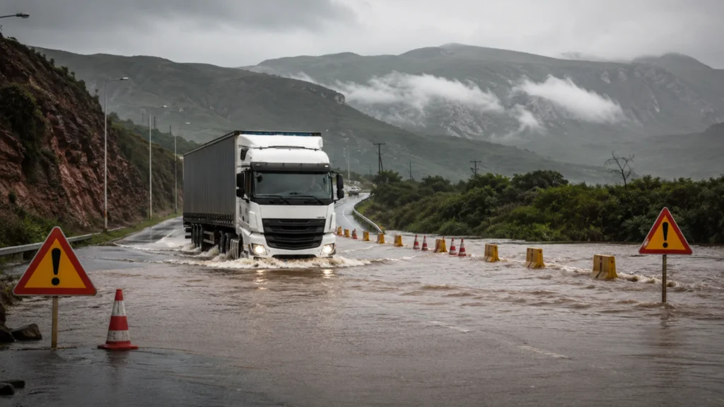
Most alarmingly, Xinhua photographed a freight truck washed away by flooding in the Garden Route District on 8 May. Vehicles that enter flood zones risk engine damage from water ingestion, electrical system failure, cargo damage, and total loss if the current is strong enough to move the vehicle. At current vehicle prices — R500,000 or more for a Hilux or Ranger — a single stranded vehicle represents a catastrophic financial event. Moreover, recovery from flood zones is expensive, dangerous, and often delayed by the same conditions that caused the stranding.
Detours add hours and cost
As a result, with Meiringspoort closed indefinitely, fleet vehicles that normally travel between Beaufort West and Oudtshoorn via the N12 must reroute. The detour via R341 through De Rust adds time and kilometres. At diesel above R31 per litre, every additional kilometre carries measurable cost. Furthermore, detour routes that were designed for light traffic now absorb displaced heavy vehicle volumes — increasing congestion, accident risk, and road wear. Fleet fuel budgets already strained by the May price shock now face additional consumption from longer routes.
Power outages disable security
Equally concerning, flooding and storm damage cause widespread power outages. When grid power fails, depot electric fences go down, CCTV cameras lose power, access control gates fail, and fuel storage monitoring goes offline. In the Garden Route, communities have been without electricity since 4 May. Consequently, fleet depots in affected areas face the same security vulnerability that Eskom cable theft causes — except this time the cause is weather rather than crime. The result is the same: assets sit unprotected during the exact hours when chaos provides cover for theft.
Cell tower disruption blinds tracking
Likewise, severe weather damages cell tower infrastructure and disrupts cellular connectivity. Some Garden Route communities have been cut off from communication entirely. When cellular networks fail, GPS tracking units cannot transmit position data to the fleet platform. The vehicle is still tracked by GPS satellites, but the data cannot reach the control room. Fleet operators who rely on single-network SIM cards in their tracking units are most vulnerable. Multi-network SIMs that switch between Vodacom, MTN, and Telkom provide redundancy — but only if at least one network remains operational in the area.
Delivery schedules collapse
Consequently, the Garden Route is a major delivery corridor for agriculture, tourism, retail, and construction. Sixty-one closed roads mean hundreds of delayed or cancelled deliveries. Cold chain operators face spoilage risk when perishable goods cannot reach their destination on time. Construction sites lose materials and equipment deliveries. Agricultural operations miss critical planting and harvesting windows. The ripple effect extends weeks beyond the storm itself because damaged roads take time to repair and cleared routes absorb displaced traffic.
How GPS Tracking Protects Vehicles During Flood Road Closures Fleet Managers Face
Fleet management technology designed for hijacking prevention and fuel monitoring serves a critical dual purpose during severe weather events.
Real-time position monitoring
First, GPS tracking shows exactly where every vehicle is at every moment. During a flood emergency, this means the fleet manager knows which vehicles have entered affected areas, which are approaching closed roads, and which are safely on alternative routes. Without real-time tracking, a vehicle that enters a flood zone may not be missed for hours — by which time it could be stranded, damaged, or its driver in danger.
Geofencing around closed roads
Second, fleet operators can create geofences around every confirmed road closure. When a vehicle approaches a closed road, the driver receives an automated alert before entering the danger zone. This prevents the most dangerous scenario: a driver unfamiliar with local conditions attempting to cross a flooded section because they did not know the road was closed. Geofencing turns road closure data from a government announcement into an active vehicle protection system.
AI dashcam evidence for insurance claims
Third, if a vehicle is damaged by floodwater, a landslide, or a road collapse, time-stamped dashcam footage provides verified evidence for the insurance claim. The footage shows road conditions at the time, proves the driver was acting reasonably, and documents the exact circumstances of the damage. Insurers may dispute flood claims if the driver deliberately entered a known flood zone. Dashcam footage that shows the driver following an approved alternative route — and encountering unexpected flooding — strengthens the claim significantly.
Driver communication and extraction
Finally, when a vehicle becomes stranded, the GPS position enables rapid location and extraction. The fleet manager can direct recovery teams to the exact coordinates rather than relying on the driver’s verbal description of their location — which is often inaccurate in rural flood zones. For fleet operators with vehicles in the Garden Route right now, knowing the exact position of every vehicle is not a convenience. It is a safety imperative.
Insurance Considerations for Flood Road Closures Fleet Operators Must Address
Generally, most comprehensive fleet insurance policies cover flood damage as an act of nature. However, several factors can complicate claims.
Reasonable avoidance
Crucially, insurers expect fleet operators to take reasonable steps to avoid known hazards. If road closures are publicly announced and the fleet manager dispatches a vehicle into the affected area regardless, the insurer may argue the damage was avoidable. Documented evidence of route planning, geofence alerts, and driver briefings demonstrates that the fleet operator acted responsibly. GPS tracking data showing the vehicle was on an approved alternative route — rather than a closed road — provides the clearest defence.
Vehicle recovery costs
Moreover, recovering a stranded vehicle from a flood zone involves specialist equipment: heavy-duty tow trucks, cranes, and sometimes helicopter support in isolated areas. These costs often exceed the standard excess on a fleet policy. Confirm with your insurer whether recovery costs are covered separately or deducted from the vehicle damage payout. Additionally, cargo salvage, temporary storage, and replacement vehicle hire during the recovery period all generate costs that must be claimed correctly.
Water damage assessment
In addition, water ingestion can cause engine damage that is not immediately apparent. A vehicle that drives through flood water may appear functional but develop injector, turbo, or electrical failures days later as water works through the system. Fleet operators should flag every vehicle that encountered flooding for mechanical inspection, regardless of whether it shows immediate symptoms. Document the flooding exposure using GPS data (the vehicle’s exact route) and dashcam footage (the water depth encountered) to support any subsequent mechanical claim.
Seven Actions Fleet Operators Should Take Right Now
Check every vehicle’s position immediately. Open your tracking platform and confirm the current location of every vehicle in your fleet. Identify any vehicles currently in the six affected provinces — Western Cape, Eastern Cape, Northern Cape, North West, Free State, and Mpumalanga. Contact those drivers directly.
Next, geofence all confirmed road closures. Create geofences around Meiringspoort, the N2 at Bitou, Swartberg Pass, Molteno Pass, the R328 landslide, and all 61 closed Garden Route roads. When a vehicle approaches any of these zones, the system alerts both driver and fleet manager before the vehicle enters.
Additionally, programme alternative routes into the system. For Meiringspoort, use the R341 via De Rust or the N12 via George. For the N2 at Bitou, confirm whether the KwaNokuthula diversion is passable for heavy vehicles. Share alternative routes with drivers before departure — not when they reach a closed road at night in the rain.
Protect, verify, and document
Verify depot backup power is operational. If your fleet depot is in any of the six affected provinces, confirm that backup power (generator or solar with battery) is keeping security systems — CCTV, electric fence, access control — operational. A depot left unprotected during a power outage in the middle of a flood emergency is an opportunity criminals will not miss.
Furthermore, confirm dashcam cloud upload is active. Local SD card storage may fail if a vehicle is submerged or damaged. Cloud upload ensures footage is preserved regardless of what happens to the hardware. This footage is critical for insurance claims and for documenting conditions that were beyond the driver’s control.
Then, brief all drivers on flood safety protocols. Do not attempt to cross flowing water. If visibility drops below 50 metres, pull over safely and wait. Report any road damage immediately. Carry emergency equipment: reflective triangles, first aid kit, torch, and emergency contact numbers. No delivery is worth a driver’s life.
Finally, document everything for insurance. Screenshot the road closure announcements. Save the GPS route data for every vehicle that travelled through affected areas. Preserve all dashcam footage from the period. Photograph any vehicle damage immediately. This documentation supports every claim you may need to file in the coming weeks.
Who Provides the Technology That Helps Fleet Operators Navigate Flood Road Closures
The same integrated fleet management platforms that protect against hijacking and fuel theft provide critical capability during severe weather.
DigitFMS connects GPS tracking, AI dashcams, geofencing, driver identification, and fuel monitoring on a single dashboard — giving fleet managers real-time visibility of every vehicle’s position, route, and status during the emergency. The company’s 100+ franchise branches include operators in the Western Cape, Eastern Cape, and other affected provinces who provide local support and understand regional road networks. When a fleet manager needs to know whether the R341 detour through De Rust is passable for a specific vehicle type, a local franchise owner can answer from direct experience.
Cartrack, Tracker, Netstar, Ctrack, and MiX by Powerfleet all offer real-time tracking and geofencing capability that serves the same purpose. The critical requirement during a flood emergency is that the tracking platform shows live vehicle positions, supports rapid geofence creation around new road closures, and provides cloud-based dashcam storage that survives vehicle damage.
Outlook: Flood Road Closures Fleet Operators Face May Persist for Weeks
Looking ahead, SAWS has warned that disruptive weather continues through Tuesday 13 May. However, the road closure impact will last far longer than the storm. Meiringspoort requires engineering assessment and reconstruction — this could take weeks or months. The N2 at Bitou requires drainage pipe installation and road stabilisation. The R328 landslide and rockfall requires geological assessment. Bridge repairs across the Garden Route require structural engineering.
Therefore, for fleet operators, this means the alternative routes being used today will become semi-permanent for the affected corridors. Fuel budgets must account for longer distances. Delivery schedules must accommodate slower travel times. Maintenance budgets must account for rougher detour road surfaces. Insurance claims from the current event must be filed promptly before the administrative backlog builds.
Ultimately, the national disaster declaration confirms what fleet operators on the ground already know: South Africa’s road infrastructure is vulnerable to severe weather, and the impact on fleet operations is immediate, measurable, and expensive. The operators who activated real-time tracking, geofenced closed roads, briefed drivers, and documented everything will recover faster — from both the physical disruption and the financial cost. The operators who sent vehicles into affected areas without checking conditions face the worst-case outcome: stranded vehicles, damaged cargo, injured drivers, and disputed insurance claims.
Frequently Asked Questions
Which roads are closed due to flooding?
Sixty-one roads across the Garden Route are closed as of 12 May. Major closures include Meiringspoort (indefinitely), N2 at Bitou (emergency repairs), Swartberg Pass, Molteno Pass, Nature’s Valley to N2, and Avontuur to Eastern Cape boundary. The R328 is blocked by a landslide. Van Reenen Pass on the N3 faces hazardous winds.
How does the national disaster affect fleet operations?
COGTA declared a national disaster on 10 May across six provinces. Fleet operators face road closures, detours adding hours and fuel cost, risk of vehicles becoming stranded, bridge damage excluding heavy vehicles, power outages disabling depot security, and cellular disruption affecting GPS tracking connectivity.
Is the N2 open for freight?
The N2 at Bitou was closed until 06:00 on Tuesday 12 May for culvert repairs. Stop-and-go control remains while engineers stabilise the road. Fleet operators should check Western Cape Government road closure updates before dispatching. Conditions change rapidly with ongoing rainfall forecast through Tuesday.
What should fleet operators do during the emergency?
Check every vehicle’s position. Geofence all closed roads. Programme alternative routes. Verify depot backup power. Confirm dashcam cloud upload is active. Brief drivers on flood safety: do not cross flowing water, report road damage, pull over safely if visibility drops. Document everything for insurance.
How long will Meiringspoort remain closed?
The municipality confirmed an extended closure due to severe damage. Stompdrift Dam reached 139% capacity, flooding the pass extensively. Engineering assessment is needed before reopening. Alternatives: R341 through De Rust or N12 via George. Fleet operators should treat Meiringspoort as unavailable for weeks or possibly months.
Does insurance cover flood damage to fleet vehicles?
Most comprehensive policies cover flood damage as an act of nature. However, insurers may dispute claims if the driver entered a known flood zone against warnings. GPS tracking data and dashcam footage proving the driver acted reasonably strengthens the claim. Document road conditions, route data, and any vehicle damage immediately.
How does severe weather affect tracking and security systems?
Power outages disable depot electric fences, CCTV, and access control. Cell tower damage disrupts GPS tracking connectivity. Water damage can affect vehicle-mounted tracking units. Verify depot backup power is operational. Confirm tracking units are transmitting. Ensure dashcam footage uploads to the cloud rather than relying on local storage that could be water-damaged.
Sources
Department of Cooperative Governance (COGTA) — National disaster declaration, 10 May 2026; Elias Sithole statement · IOL — “Severe weather officially classified as national disaster”, 11 May 2026; “Garden Route floods: affected areas and road closures”, 7 May 2026 · Xinhua — “Severe weather causes widespread damage across Garden Route”, 9 May 2026; “National disaster declared”, 10 May 2026 (includes truck washed away photo) · TimesLive — “More storms to come in Western Cape”, 11 May 2026; 61 roads closed, R328 landslide · IOL — “Severe storm hits Cape Town: Level 8 alert remains”, 11 May 2026 · Western Cape Government — Road closures due to Level 8 rainfall, 7 May 2026 · George Municipality — Multi-Agency Command Centre alerts 7-13, May 2026 · Garden Route District Municipality — Flooding status updates, May 2026 · George Herald — Road closures and infrastructure updates, 7-10 May 2026 · Knysna-Plett Herald — Multi-Agency Command Centre update, 7 May 2026 · Oudtshoorn Courant — Flooding status updates, 7-10 May 2026 · The Watchers — “More than 300 mm rain triggers flooding and evacuations”, 7 May 2026 · South African Weather Service — Level 8 warning extension through 13 May 2026 · The South African — “Table Mountain National Park closes”, “Schools closed 12 May”, 11 May 2026
© 2026 DigitFMS. All rights reserved.